fleet.wikisort.org - Lighthouse
Nida Lighthouse (Lithuanian: Nidos švyturys) is located in Nida, on the Curonian Spit in between the Curonian Lagoon (to the east) and the Baltic Sea (to the west).[2]
 | |
 | |
| Location | Curonian Spit, Nida, Neringa Municipality, Lithuania |
|---|---|
| Coordinates | 55°18′18″N 20°59′42″E |
| Tower | |
| Constructed | 1945 |
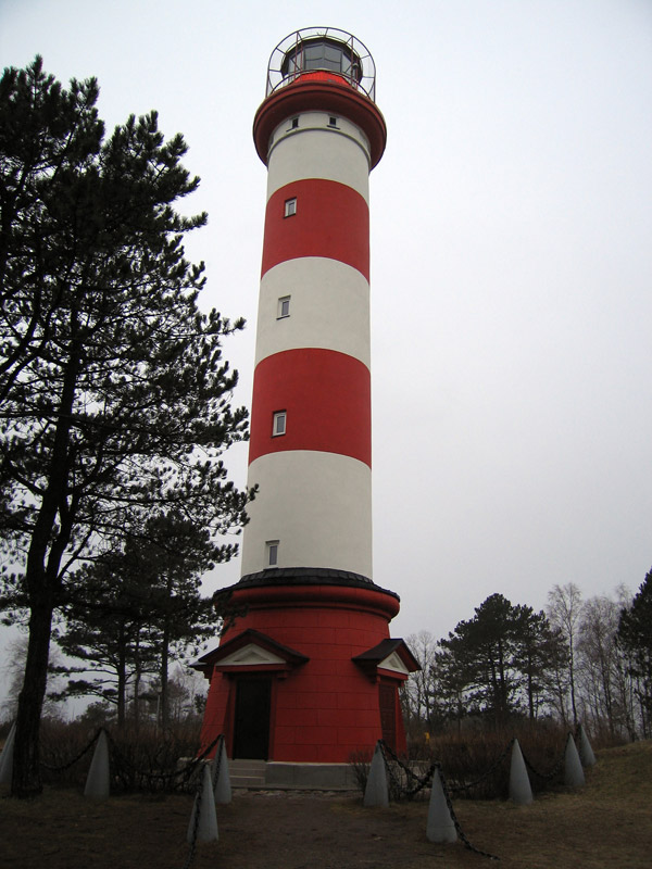
| Construction | reinforced concrete |
| Height | 27 m (89 ft) |
| Shape | cylindrical tower with balcony and lantern[1] |
| Markings | red (lantern) |
| Operator | Curonian Spit National Park |
| Light | |
| First lit | 1945, 1953 |
| Focal height | 76 m (249 ft) |
| Range | 22 nmi (41 km; 25 mi) |
| Characteristic | Fl(2) W 5.8s |
| Lithuania no. | LT-0050 |
| Original light | |
 | |
| Constructed | 1874 |
| Construction | brick (tower) |
| Markings | red (tower) |
| First lit | 24 October 1874 |
| Deactivated | 1944 |
History
The original lighthouse in Nida was constructed in the 1860s and 1870s during the German Unification. Twenty-seven metres high and built of red brick, it had 200 steps, which have survived to this day. It was planned to be 51.4 metres high, on raised ground, and built by prisoners. It was first lit on October 24, 1874.
In 1944, at the end of the Second World War, German soldiers blasted the lighthouse, destroying it. It was rebuilt in 1945 and renovated in 1953. The current lighthouse is built of reinforced concrete with horizontal red and white stripes.[3][1]
See also
- List of lighthouses in Lithuania
References
| Wikimedia Commons has media related to Nidos švyturys. |
- Rowlett, Russ. "Lighthouses of Lithuania". The Lighthouse Directory. University of North Carolina at Chapel Hill. Retrieved February 19, 2016.
- "Lithuanian Lighthouses". MSA Official Website Of Navigation Lights. Archived from the original on 8 May 2015. Retrieved 13 May 2015.
- Rowlett, Russ. "Lighthouses of Lithuania". The Lighthouse Directory. University of North Carolina at Chapel Hill. Retrieved 13 May 2015.
| Authority control: Lighthouse identifiers |
|
|---|
This article about a Lithuanian building or structure is a stub. You can help Wikipedia by expanding it. |
This European lighthouse-related article is a stub. You can help Wikipedia by expanding it. |
На других языках
- [en] Nida Lighthouse
[ru] Нидский маяк
Нидский маяк (лит. Nidos švyturys) или Маяк горы Урбас (лит. Urbo kalno švyturys) — береговой маяк на Куршской косе в посёлке Нида, расположен примерно в 900 метрах от берега Балтийского моря, на вершине песчаного холма Урбас.Другой контент может иметь иную лицензию. Перед использованием материалов сайта WikiSort.org внимательно изучите правила лицензирования конкретных элементов наполнения сайта.
WikiSort.org - проект по пересортировке и дополнению контента Википедии