fleet.wikisort.org - Lighthouse
Utvær Lighthouse (Norwegian: Utvær fyr) is the westernmost coastal lighthouse in Norway. It is located in the western part of Solund municipality in Vestland county.
 View of the lighthouse | |
 | |
| Location | Solund Vestland Norway |
|---|---|
| Coordinates | 61°02′13″N 04°30′36″E |
| Tower | |
| Constructed | 1900 |
| Construction | cast iron tower |
| Automated | 2004 |
| Height | 31 metres (102 ft) |
| Shape | cylindrical tower with balcony and lantern |
| Markings | red tower and lantern |
| Heritage | cultural property |
| Light | |
| Focal height | 45 metres (148 ft) |
| Intensity | 2,005,000 candela |
| Range | 18.6 nmi (34.4 km; 21.4 mi) |
| Characteristic | Fl W 30s. |
History
It was first lit in 1900 and it was listed as a protected site in 1999. The surrounding area is protected as a nature reserve. It is located on a small, rocky island about 6.5 kilometres (4.0 mi) due west of the island of Ytre Sula. The site is accessible only by boat, but guided tours are available.[1][2]
The 31-metre (102 ft) tall, round, cast iron tower is painted red. At the top sits a light that emits a white flash every 30 seconds at an elevation of 45 metres (148 ft) above sea level. The lighthouse marks the line of transition between the North Sea to the southwest and the Norwegian Sea to the northwest. The light station was heavily damaged in an air raid during World War II in 1945. Many of the buildings were burned, but the historic tower was spared.[3][4]
Utvær lighthouse is currently displayed on the 50-kroner Norwegian banknote.[5]
Gallery
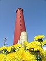 Closeup of the tower
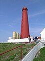 View of the lighthouse complex
 View of the lighthouse and the local village
 Alternate view


See also
- Lighthouses in Norway
- List of lighthouses in Norway
References
- Godal, Anne Marit (ed.). "Utvær fyr". Store norske leksikon (in Norwegian). Oslo: Norsk nettleksikon. Retrieved 13 February 2012.
- "Utvær fyrstasjon" (in Norwegian). Norsk Fyrhistorisk Forening. Retrieved 13 February 2012.
- Rowlett, Russ (19 July 2011). "Lighthouses of Norway: Sognefjord Area". The Lighthouse Directory. University of North Carolina at Chapel Hill. Retrieved 2013-12-16.
- Kystverket (2012). Norske Fyrliste 2012 (PDF) (in Norwegian). ISBN 9788245013542. Archived from the original (PDF) on 2013-09-21. Retrieved 2013-08-04.
- "New 50-krone note - motifs". Retrieved 2018-10-24.
External links
- Norsk Fyrhistorisk Forening (in Norwegian)
This Norwegian lighthouse-related article is a stub. You can help Wikipedia by expanding it. |
На других языках
- [en] Utvær Lighthouse
[ru] Утверский маяк
Утверский маяк или маяк Утвер-фюр (норв. Utvær fyr) — действующий маяк на скалистом островке, входящем в группу шхер Утвер (норв. Utvær), расположенных приблизительно в 7 км к западу от острова Итре Сула (норв. Ytre Sula), на границе Норвежского и Северного морей близ юго-западного побережья Норвегии.Другой контент может иметь иную лицензию. Перед использованием материалов сайта WikiSort.org внимательно изучите правила лицензирования конкретных элементов наполнения сайта.
WikiSort.org - проект по пересортировке и дополнению контента Википедии