fleet.wikisort.org - Lighthouse
Booby Island Light is an active heritage-listed lighthouse located on Booby Island in the Shire of Torres, near the tip of Cape York Peninsula, west of Prince of Wales Island, within the Endeavour Strait, Queensland, Australia. It marks the western entrance to the navigation channel through the Torres Strait.[5] It was the last of the major lights to be constructed along the Queensland coast.[6]
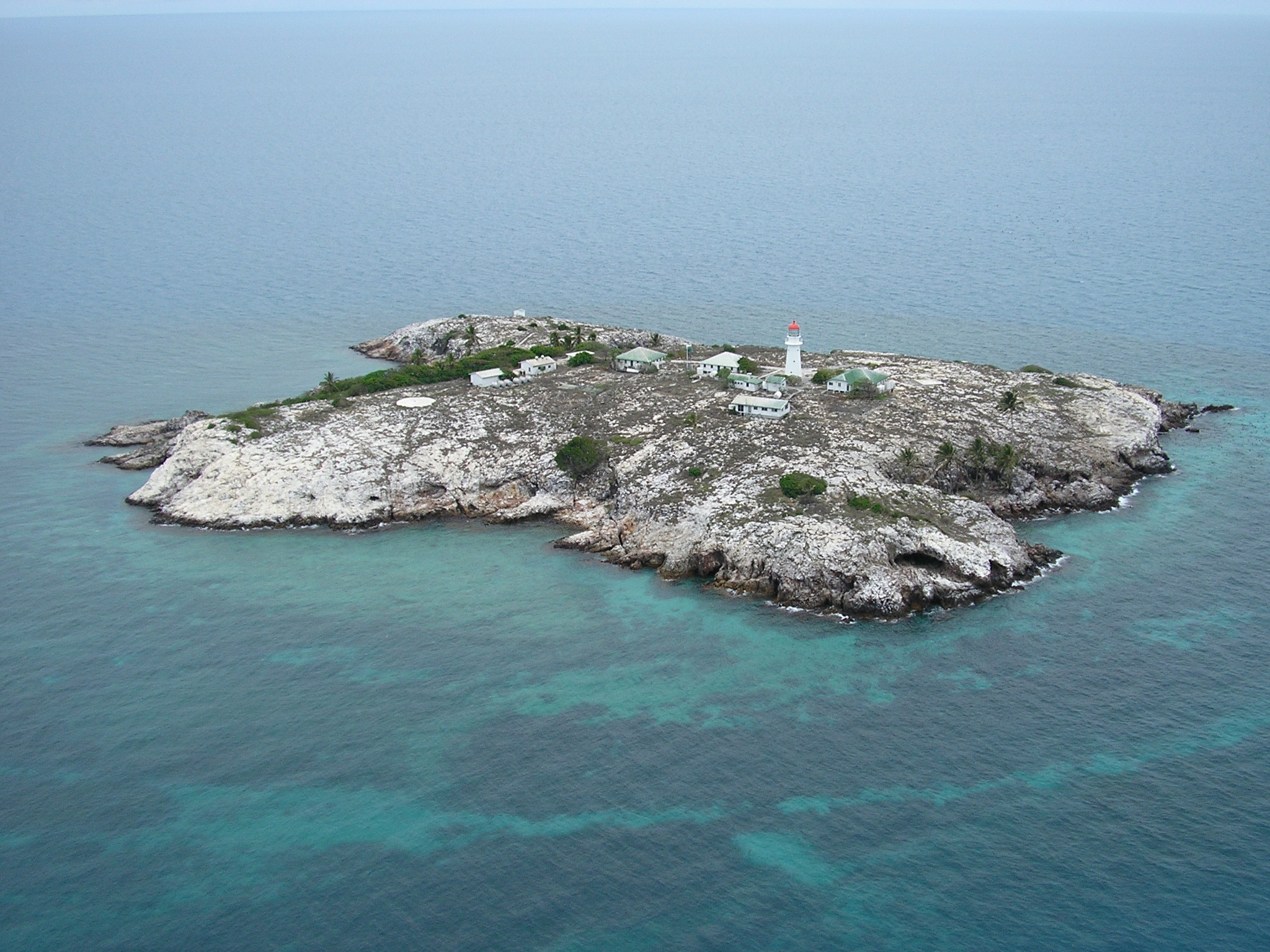
 Booby Island Lighthouse and one of the deteriorated cottages | |
 | |
| Location | Booby Island, Queensland, Australia |
|---|---|
| Coordinates | 10°36′20″S 141°54′33″E |
| Tower | |
| Constructed | 1890 |
| Construction | timber frame clad with galvanised iron[1] |
| Automated | 1992 |
| Height | 59 feet (18 m)[2] |
| Shape | conical tower with balcony and lantern |
| Markings | white (tower), red (dome) |
| Heritage | listed on the Queensland Heritage Register, listed on the Register of the National Estate |
| Light | |
| Focal height | 121 feet (37 m)[3] |
| Lens | second order Fresnel lens |
| Range | 20 nmi (37 km; 23 mi) |
| Characteristic | Fl W 10s.[4] |
History
The colony of Queensland was formed in 1859. In 1862, the Queensland government appointed the first Portmaster, Commander George Poynter Heath. During the following years, several committees were held, but none of them recommended the erection of a lighthouse on Booby Island. It was Heath who first recommended the construction of such a lighthouse, at the Intercolonial Conference of Marine Departments in 1873,[6] where a first order light was finally recommended by the delegates.[7] However, this recommendation was not followed through, and it was only in August 1885 that Heath referred to the lighthouse again, as trade through the Torres Strait increased, and a traffic channel west of the Prince of Wales Island was established. Formal approval took four more years, and tenders for the lighthouse were called in April 1899. The accepted tender of £3329 was by the brothers John and Jacob Rooney of Maryborough, which also constructed Sandy Cape Light, Cape Bowling Green Light, Cowan Cowan Point Light, Cape Capricorn Light and Lady Elliot Island Light. The light was first exhibited on 24 June 1890, and the total cost of construction was £6,500. Residences for the lighthouse keepers were also constructed in 1890.[6]

The original lens was a second order Chance Brothers Fresnel lens, with a focal radius of 800 millimetres (31 in), mounted on a rotating pedestal with mercury bearings. The light source was an oil wick burner with an intensity of 20,000 cd. In 1917 the light source was upgraded to an 85 millimetres (3.3 in) vaporised kerosene mantle, with an intensity of 120,000 cd.[7]
In 1961 a radio beacon was installed. In 1963 the lighthouse was converted to electricity. The light source at that time was a 120 Volt 1,000 Watt tungsten-halogen lamp providing 1,000,000 cd and visible for 26 nautical miles (48 km; 30 mi). The light characteristic was one flash every four seconds (Fl.W. 4s). A tide gauge was installed in 1970.[7]
In November 1991 the power source was converted to solar power. The original lens and the pedestal were removed, the mercury drained, and the entire apparatus replaced with a modern rotating mechanism. The original apparatus now resides in the Thursday Island Museum. The battery banks were installed in the ground floor of the tower.[7] The light characteristic was changed to the current, one white flash every ten seconds (Fl.W. 10s),[4] and it is visible for 20 nautical miles (37 km; 23 mi).[8] The light was fully automated and demanned in 1992.[6]
Structures
The lighthouse is conical, 18 metres (59 ft)[2] high, made of timber frame clad with galvanised iron. The tower is topped by the original 10 feet 1 inch (3.07 m) diameter Chance Brothers lantern. It is painted white, with red dome[7] of sheet copper. The dome is topped by a rounded knob and a weather vane.[6]

The residences include four cottages, three for the resident lighthouse keepers and an additional relief quarters.[7] The resident keeper residences were built in 1890, and then renovated twice, in the 1920s and 1960s.[6] They are timber-framed, clad with weatherboards and fibre cement.[6] Also associated with these quarters is a glasshouse, timber-framed with external concrete block walls and a corrugated asbestos cement roof.[6] The relief quarters, built in the late 1960s or early 1970s,[9] are timber-framed with external walls of asbestos sheeting and a roof of corrugated asbestos cement.[6]
Other buildings in the station include a radio equipment building that doubles as an office, a powerhouse with a fuel store, the tide gauge hut, the radio beacon transmitter building and a workshop. The radio equipment building is timber-framed with external painted concrete block walls and corrugated asbestos cement roof.[6] The powerhouse and the fuel store are constructed of concrete blocks with a corrugated zinc sheeted roof.[6] The powerhouse houses three diesel alternators which provide power to the station.[7] The tide gauge hut, constructed in 1970, is timber-framed with fibre cement sheeting, a galvanised metal deck and an aluminium louvre mechanism. The radio beacon transmitter building, constructed in 1961, is built of concrete blocks with timber framed doors and aluminium hopper windows. Finally, the workshop is timber-framed with fibre cement walls and corrugated asbestos cement roof.[6]
Site operation and visiting
The light is operated by the Australian Maritime Safety Authority. The site is managed by the Queensland Parks and Wildlife Service. The location is accessible only by boat, and a special permit is required for landing. Both the tower and the location are closed to the public.[5]
Heritage listing
The lighthouse was listed on the Queensland Heritage Register in 1998.[10]
See also
- List of lighthouses in Australia
Notes
- AHD19045 and QLD601724. Rowlett says cast iron.
- List of Lights, Rowlett and AHD19045. QLD601724 states 16m.
- List of Lights. Rowlett lists 120 feet (37 m).
- List of Lights. Rowlett lists 7.5s.
- Rowlett.
- QLD601724.
- AHD19045.
- List of Lights
- The plans for the relief quarters, e.g. in the National Archives of Australia, were signed in January 1969, suggesting late 1960s or early 1970s construction date.
- "Booby Island Lightstation (entry 601724)". Queensland Heritage Register. Queensland Heritage Council. Retrieved 1 July 2013.
References
- List of Lights, Pub. 111: The West Coasts of North and South America (Excluding Continental U.S.A. and Hawaii), Australia, Tasmania, New Zealand, and the Islands of the North and South Pacific Oceans (PDF). List of Lights. United States National Geospatial-Intelligence Agency. 2009. p. 189.
- Rowlett, Russ. "Lighthouses of Australia: Far North Queensland". The Lighthouse Directory. University of North Carolina at Chapel Hill. Retrieved 14 November 2010.
- "Booby Island Lightstation, Booby Island via Thursday Island, QLD, Australia (Place ID 19045)". Australian Heritage Database. Australian Government. Retrieved 24 November 2010.
- "Booby Island Lightstation". Queensland Government. 9 June 2015.
External links
- "List of Lighthouses of Queensland". Lighthouses of Australia. Lighthouses of Australia Inc.
- Searle, Garry. "List of Lighthouses - Queensland". Lighthouses of Australia. SeaSide Lights.
Lighthouses of Queensland | ||||||
|---|---|---|---|---|---|---|
| South East Coast |
|  | ||||
| Central Coast | ||||||
| North Coast | ||||||
| Far North Coast | ||||||
| Torres Strait | ||||||
| ||||||
List of Torres Strait topics | |||||||||||||||||||
|---|---|---|---|---|---|---|---|---|---|---|---|---|---|---|---|---|---|---|---|
| Torres Strait Islands, islets, and cays |
| ||||||||||||||||||
| People, culture, communities and languages |
| ||||||||||||||||||
| Governance and legal matters |
| ||||||||||||||||||
| Buildings and structures | |||||||||||||||||||
| Other |
| ||||||||||||||||||
Другой контент может иметь иную лицензию. Перед использованием материалов сайта WikiSort.org внимательно изучите правила лицензирования конкретных элементов наполнения сайта.
WikiSort.org - проект по пересортировке и дополнению контента Википедии