fleet.wikisort.org - Lighthouse
Cape Ray is a headland located at the southwestern extremity of the island of Newfoundland in the Canadian province of Newfoundland and Labrador.
 | |
 | |
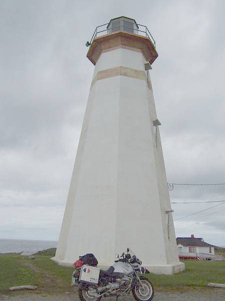
| Location | Cape Ray, Newfoundland and Labrador, Canada |
|---|---|
| Coordinates | 47°37′16″N 59°18′14″W |
| Tower | |
| Constructed | 1871 (first) 1885 (second) |
| Foundation | concrete base |
| Construction | wooden tower (first and second) concrete tower (current) |
| Height | 15 metres (49 ft) |
| Shape | hexagonal tower (first) octagonal tower with balcony and lantern (second and current) |
| Markings | white tower with a narrow red horizontal band |
| Operator | South West Coast Development Association[1][2] |
| Heritage | recognized federal heritage building of Canada, heritage lighthouse |
| Light | |
| First lit | 1959 (current) |
| Deactivated | 1885 (first) 1959 (second) |
| Focal height | 37 metres (121 ft) |
| Range | 17 nautical miles (31 km; 20 mi) |
| Characteristic | Fl W 15s |
It is the site of the Cape Ray Lighthouse. It is located opposite Cape North on Cape Breton Island, Nova Scotia. Cape Ray the community takes its name from this historic landmark.
See also
- List of lighthouses in Canada
References
- Rowlett, Russ. "Lighthouses of Canada: Southwestern Newfoundland". The Lighthouse Directory. University of North Carolina at Chapel Hill. Retrieved 2017-02-11.
- List of Lights, Pub. 110: Greenland, The East Coasts of North and South America (Excluding Continental U.S.A. Except the East Coast of Florida) and the West Indies (PDF). List of Lights. United States National Geospatial-Intelligence Agency. 2016.
External links
- Cape Ray Lighthouse
- Aids to Navigation Canadian Coast Guard
Wikimedia Commons has media related to Cape Ray.
Lighthouses of Canada | |
|---|---|
| British Columbia |
|
| Manitoba |
|
| New Brunswick |
|
| Newfoundland and Labrador |
|
| Nova Scotia |
|
| Ontario |
|
| Prince Edward Island |
|
| Quebec |
|
This Newfoundland and Labrador location article is a stub. You can help Wikipedia by expanding it. |
На других языках
[de] Cape Ray
Cape Ray ist ein Kap im äußersten Südwesten der Insel Neufundland in der kanadischen Provinz Newfoundland and Labrador.- [en] Cape Ray
Текст в блоке "Читать" взят с сайта "Википедия" и доступен по лицензии Creative Commons Attribution-ShareAlike; в отдельных случаях могут действовать дополнительные условия.
Другой контент может иметь иную лицензию. Перед использованием материалов сайта WikiSort.org внимательно изучите правила лицензирования конкретных элементов наполнения сайта.
Другой контент может иметь иную лицензию. Перед использованием материалов сайта WikiSort.org внимательно изучите правила лицензирования конкретных элементов наполнения сайта.
2019-2026
WikiSort.org - проект по пересортировке и дополнению контента Википедии
WikiSort.org - проект по пересортировке и дополнению контента Википедии