fleet.wikisort.org - Lighthouse
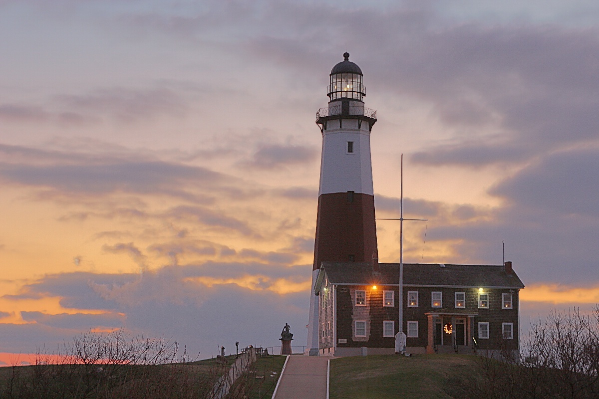
The Montauk Point Light, or Montauk Point Lighthouse, is a lighthouse located adjacent to Montauk Point State Park, at the easternmost point of Long Island, in the hamlet of Montauk in the Town of East Hampton in Suffolk County, New York. The lighthouse was the first to be built within the state of New York, and was the first public works project of the new United States. It is the fourth oldest active lighthouse in the United States.[4] Long Island listed on the National Register of Historic Places, in 2012, it was designated as a National Historic Landmark for its significance to New York and international shipping in the early Federal period.
 (2009) | |
 | |
| Location | Montauk Point, Suffolk County, New York |
|---|---|
| Coordinates | 41°04′16″N 71°51′26″W |
| Tower | |
| Foundation | 13 ft (4 m) deep and 9 ft (3 m) thick, Natural, Emplaced, built in 1796 |
| Construction | Sandstone |
| Automated | 1987 |
| Height | 110.5 ft (33.7 m) structure |
| Shape | Octagonal pyramidal |
| Markings | Tower painted white with a broad red band midway, lantern black[1][2] |
| Heritage | National Historic Landmark, National Register of Historic Places listed place |
| Fog signal | Horn: 1 2s in every 15s |
| Light | |
| First lit | 1797 |
| Focal height | 168 ft (51 m) |
| Lens | 8 whale oil lamps (1797), Fresnel lens (later), VRB-25 (current) |
| Range | 18 nm |
| Characteristic | Flashing White 5 seconds. |
Montauk Point Lighthouse | |
U.S. National Register of Historic Places | |
U.S. National Historic Landmark | |
| Nearest city | East Hampton, New York |
| Area | less than one acre |
| Built | 1796 |
| Architect | McComb, Jr., John |
| NRHP reference No. | 69000142 [3] |
| Significant dates | |
| Added to NRHP | July 07, 1969 |
| Designated NHL | March 2, 2012 |
The lighthouse, which is located on Turtle Hill at the easternmost tip of Long Island, at 2000 Montauk Highway, is a privately run museum, and is not part of Montauk Point State Park. Entry to the lighthouse costs $13.00 for an adult, $8.00 for seniors and $5.00 per child.[5]
History
Montauk Light was the first lighthouse in New York State, and is the fourth-oldest active lighthouse in the United States. The tower is 110'6" high. The current light, installed in July 2001, equivalent to approximately 290,000 candle power, flashes every 5 seconds and can be seen a distance of 19 nautical miles (35 km).[4]
Construction on the lighthouse was authorized by the Second United States Congress, under President George Washington on April 12, 1792. Ezra L'Hommedieu, a prominent lawyer, member of the Continental Congress,[6] and a man with scientific interests, consulted with Washington on its construction. He represented the New York City Chamber of Commerce on discussions related to the lighthouse. He made the case that New York City "was first among American ports in the volume of its foreign commerce. By 1797, the harbor was handling a third of the nation's trade with other countries."[7] Due to prevailing winds in winter, shippers approaching from sea needed a lighthouse at the end of Long Island to guide them along the south side into New York harbor.[7]

L'Hommedieu chose the site for the lighthouse[8] and designed it.[7] The project began on June 7, 1796, and was completed on November 5, 1796, the first public works project of the new United States of America. Sometime in early April 1797, keeper Jacob Hand lit the wicks in the lamps in the tower, and the lighthouse began operation. It continued under civilian keepers until World War II, when the US Army took it over.[9]
In 1860, the lighthouse station underwent a massive renovation when two new levels and a larger lantern were added. This increased the height of the tower from its original 80 feet (1796) to its current height of 110' 6". A first-order Fresnel lens—12 feet high, 6 feet in diameter, and weighing about 10,000 pounds—was installed in the new lantern; the current keeper's dwelling was constructed adjacent to the tower, and the original 1796 dwelling was demolished. A steam-powered fog signal was installed in 1873, with a fog signal building in 1897. The tower was originally all white; its single brown stripe was added in 1899. A fourth-order fixed red range-light was added to the watch deck of the tower in 1903 to warn of Shagwong Reef, a navigational hazard about 31⁄2 miles northwest of the lighthouse. This light was severely damaged in the hurricane of September 21, 1938 and removed on July 1, 1940 when the lighthouse was electrified. The huge first-order Fresnel lens was replaced in 1903 with a 31⁄2 order bivalve Fresnel lens, which served until February 3, 1987, when it was replaced with an airport beacon with a strength of 2.5 million candela.

During World War II, the lighthouse was taken over by the U.S. Army as part of the Eastern Coastal Defense Shield. The last three civilian keepers—Thomas Buckridge, Jack Miller, and George Warrington—departed in the spring of 1943. Adjacent to the lighthouse, Camp Hero, opened by the Army in 1942, had two 16 inch gun batteries of two guns each, and a battery of two six-inch guns. The casemates, gun emplacements and concrete fire control towers (which are also at nearby Shadmoor State Park) are still visible.
In 1946 the United States Coast Guard took over maintenance of the lighthouse and operated it until the station was automated on February 3, 1987. In May of that year, the lighthouse museum opened to the public, operated by the Montauk Historical Society. It leased the property from the US Coast Guard for that purpose. On September 30, 1996 President Bill Clinton signed legislation transferring the lighthouse property to the Montauk Historical Society.
The tower was built on Turtle Hill 300 feet (90 m) from the edge of the cliff; due to the cumulative effects of shoreline erosion, it is now 100 feet (30 m) away from the edge. After World War II, the United States Army Corps of Engineers built a seawall at its base, but the erosion continued. The Coast Guard considered tearing down the lighthouse in 1967 and replacing it with a steel tower further from the edge of the bluff. In the wake of protests over the announced dismantling of the tower, Congressman Michael Forbes proposed a bill to the United States Congress to hand over the Lighthouse to the Montauk Historical Society from the Public so it could be preserved;[10] the bill was passed.
Giorgina Reid (1908–2001), a textile designer, had saved her Rocky Point, New York cottage from collapse by building a simple set of terraces in the gullies of the bluff. She proposed that solution to the Society at Montauk. Reid's concept, Reed-Trench Terracing, called for building the terrace platforms made of various beach debris, notably reeds; the practice (along with further strengthening of the rocks at the bluff toe) appeared to stem the erosion. She patented the process and published an article about it titled "How to Hold up a Bank".[11] Greg Donohue, a Montauk landscaper, worked with Reid at the Point and kept the project moving forward after she retired in 1986. With support from various sources, including the Montauk Historical Society and the State of New York, the Erosion Control Project of Montauk Point was successfully completed in 1998.[12][13][dubious ]
However, the recurrence of the erosion threat in ensuing years has prompted further action: In November 2006, the United States Army Corps of Engineers' plan to build another seawall was opposed by a local surfing group, who contended that a seawall would ruin the nearby world-renowned surf break. They proposed moving the lighthouse back from the shore, as was done with the Cape Hatteras Lighthouse.[14] Complicating such a move is the terrain, which would require the lighthouse to be moved down one hill and up another. Environmental groups have raised concerns that reducing the erosion at Montauk would increase erosion at other Long Island beaches, as there are always related effects to such infrastructure work.[15]
On March 2, 2012 United States Secretary of the Interior Ken Salazar officially designated the lighthouse as a National Historic Landmark; it is the 14th site on Long Island and the 11th lighthouse in the country to be so recognized.
The United States Army Corps of Engineers announced on January 13, 2020 the award of a $30.7 million contract to H&L Contracting of Bayshore, New York, to restore and protect the lighthouse from shoreline erosion. Work is expected to start Spring 2020 and last approximately two years. The approximately 1,000 linear feet stone revetment work consists of removing and reusing existing five- and 10-ton armor stones, placement of new 10- and 15-ton armor stones, and providing slope stabilization with terracing and vegetation above the upper crest of the revetment. The total project is anticipated to cost $30.7 million. Costs are shared by the project’s sponsors. New York State Department of Environmental Conservation is committing $15.4 million in NY Works funding as the project’s non-federal sponsor. The local sponsor, the Montauk Historical Society, will maintain the site after construction is complete.[16]
Suffolk Transit's 10C bus route serves the lighthouse, connecting it with Montauk Village.
Pirate Captain Kidd was said to have buried treasure at the foot of the lighthouse site around 1699 at two ponds which today are called "Money Ponds."[17]
Gallery
 View from the top of the lighthouse

 Montauk Point Lighthouse, on a NOAA nautical chart


References
Notes
- Light List, Volume I, Atlantic Coast, St. Croix River, Maine to Shrewsbury River, New Jersey (PDF). Light List. United States Coast Guard. 2009. p. 8.
- "Historic Light Station Information and Photography: New York". United States Coast Guard Historian's Office. Archived from the original on 2017-05-01.
- "National Register Information System". National Register of Historic Places. National Park Service. March 13, 2009.
- "Lighthouse Facts". Montauk Light House.com. Archived from the original on 2008-06-16. Retrieved 2008-06-24.
- "Plan Your Lighthouse Visit". Retrieved 20 July 2022.
- Mac Griswold, The Manor: Three Centuries at a Slave Plantation on Long Island, New York: Farrar, Straus and Giroux, 2013, p. 263
- Russell Drumm, "Turning a Montauk Beacon Into a Landmark", Easthampton Star, 2 June 2011, accessed 4 December 2013
- Henry Osmer, "Montauk Point Lighthouse Awarded National Landmark Status", Lighthouse Digest, Sep-Oct 2012, accessed 4 December 2012
- William G. Tyrrell (May 1969). "National Register of Historic Places Registration: Montauk Point Lighthouse". New York State Office of Parks, Recreation and Historic Preservation. Archived from the original on 2012-10-09. Retrieved 2010-02-20. See also: "Accompanying photo".
- Montauk Point Lighthouse Museum (Local Legacies)
- "Against All Odds: A Lighthouse Looks To The Future", Greg Donohue, Official Montauk Lighthouse website, (archive)
- Raimondo, Lois (March 13, 1998). "Erosion Project For Lighthouse Nears Completion". The New York Times. Retrieved July 10, 2022.
- Lambert, Bruce (August 8, 1999). "For the Island's Icon, A New Lease on Life". The New York Times. Retrieved July 10, 2022.
- Kilgannon, Corey (November 14, 2006). "For Montauk, It's Lighthouse vs. Surf's Up!". The New York Times. Retrieved 2009-09-02.
- Dean, Cornelia (November 21, 2006). "The Coastline Is Retreating. Should the Montauk Lighthouse Stand Its Ground?". The New York Times. Retrieved 2009-09-02.
- "U.S. Army Corps of Engineers Announces $30.7 Million Contract Awarded to Restore and Protect Montauk Point Lighthouse", retrieved 14 January 2021
- Pirates and Prohibition - Excerpted From East Hampton History, by Jeannette Edwards Rattroy - 1953 (republished on longislandgeneology.com - Retrieved 2007-01-12)
Further reading
Books by Henry Osmers, published by Outskirts Press:
- On Eagle's Beak: A History of the Montauk Point Lighthouse, 2008.
- Living on the Edge: Life at the Montauk Point Lighthouse 1930–1945, 2009.
- They Were All Strangers: the Wreck of the John Milton at Montauk, New York, 2010.
- American Gibraltar: Montauk and the Wars of America, 2011.
External links
- The Official Montauk Point Lighthouse Web Site
- National Park Service List of New York Lighthouses
- New York State Parks: Montauk Point State Park

.jpg)
U.S. National Register of Historic Places in New York | ||
|---|---|---|
| Topics |
|  |
| Lists by county |
| |
| Lists by city |
| |
| Other lists |
| |
| ||
| Authority control: Lighthouse identifiers |
|
|---|
На других языках
- [en] Montauk Point Light
[ru] Маяк Монток-Пойнт
Маяк Монток-Пойнт (англ. Montauk Point Light) — маяк, расположенный на самой восточной точке острова Лонг-Айленд — мысе Монток-Пойнт, округ Саффолк, штат Нью-Йорк, США. Построен в 1797 году. Автоматизирован в 1987 году. Является вторым по высоте действующим маяком штата Нью-Йорк после маяка острова Файр, 42-й по высоте маяк страны.Другой контент может иметь иную лицензию. Перед использованием материалов сайта WikiSort.org внимательно изучите правила лицензирования конкретных элементов наполнения сайта.
WikiSort.org - проект по пересортировке и дополнению контента Википедии