 Cap-des-Rosiers Lighthouse & Foghorn Building
 The walls are over seven feet thick at the base, tapering to three feet at the top.
 Looking down from the lantern at the stairs that lead up the tower.
 The light source is now an electric discharge lamp. This is an occulting light, a rhythmic light in which the duration of light in each period is longer than the total duration of darkness, accomplished by this vertical rotating shutter which periodically shades the light from view. In this case, the light shines for 15 seconds, and eclipses (goes dark) for 5 seconds, and repeats.
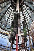 The rotating shutter periodically shades the light from view.
 The lamp manufacturer's plaque: L. Sautter & Cie. Constructeurs A Paris.
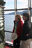 The optic in the lantern, with the shoreline of the Gaspé Peninsula in the distance.
 The optic in the lantern, with the shoreline of the Gaspé Peninsula and the St. Lawrence River in the distance.
fleet.wikisort.org - Lighthouse
The Cap-des-Rosiers Lighthouse (French: Phare de Cap-des-Rosiers) is a lighthouse near the village of Cap-des-Rosiers in Gaspé, Quebec, Canada.
 Cap-des-Rosiers Lighthouse | |
 | |
| Location | Gaspé Quebec Canada |
|---|---|
| Coordinates | 48°51′22.5″N 64°12′03.8″W |
| Tower | |
| Constructed | 1858 |
| Foundation | stone, up to 8' deep |
| Construction | limestone tower, faced with white marble[1] |
| Automated | 1981 |
| Height | 34.1 metres (112 ft) |
| Shape | cylindrical tower with balcony and lantern |
| Markings | white tower, red lantern and trim |
| Heritage | national Historic Sites of Canada, classified federal heritage building of Canada |
| Light | |
| Focal height | 41.5 metres (136 ft) |
| Lens | first-order fresnel lens[1] |
| Range | 24 nautical miles (44 km; 28 mi)[2] |
| Characteristic | Oc W Flash 15 s; eclipse 5 s. Year round[2] |
National Historic Site of Canada | |
| Official name | Cap-des-Rosiers Lighthouse National Historic Site of Canada |
| Designated | May 18, 1974 |
| Reference no. | 75521 |
National Historic Site of Canada | |
| Official name | Lighttower, Highway 132, Gaspé, Quebec, Canada |
| Type | Classified Federal Heritage Building |
| Designated | March 31, 1994 |
| Reference no. | 4383 |
It was classified as a National Historic Site of Canada on June 11, 1973.[3] It was listed as a Federal Heritage Building on March 31, 1994.[4]
The Cap-des-Rosiers Lighthouse is the tallest lighthouse in Canada, standing 34.1 metres (112 ft) tall. It is situated on the south shore of the Saint Lawrence River at the top of a steep cliff. It is located at the mouth of the river, where it flows into the Gulf of St. Lawrence. It is open for tours in the summer season.

Historic Sites and Monuments Board of Canada
The Historic Sites and Monuments Board of Canada installed a plaque at the base of the lighthouse in 1977, with inscriptions in French and English, which reads (in English):
Built in 1858, this lighthouse is one of a series of tall, tapering towers erected on the Gulf of St. Lawrence and on Lake Huron by the Department of Public Works. The 112 foot structure is the tallest lighthouse in Canada; its stone tower faced with firebrick has walls over seven feet thick at the base, tapering to three feet at the top, with foundations extending to eight feet beneath the surface. Originally a dwelling was attached to the tower. A powerful light 136 feet above high water served as a major coastal aid for shipping headed in the estuary of the St. Lawrence from the Gulf.
Keepers
- Eugène Trudeau 1856-1867[5]
- Auguste Trudeau 1867-1886
- Jean B. Vien 1886-1890
- Eugène Costin 1890-1915
- P. E. Theriault 1915-1920
- J. Napoléon Côté 1920-1927
- J. Ferguson 1927-1931
- J. Napoléon Côté 1931-1935
- Joseph Ferguson 1935-1951
- Joseph-Narcisse Rioux 1951-1970
- Yves Packwood 1970-1971
- Owen Gleeton 1971-1972
- Paul-Roger Caron 1972-1978
- Yvon Élément 1978-1981
See also
- List of lighthouses in Canada
Gallery
Cap-des-Rosiers Lighthouse


References
- Anderson, Kraig. "Cap des Rosiers Lighthouse". Lighthousefriends.com. Lighthousefriends.com. Retrieved April 11, 2020.
- List of Lights, Pub. 110: Greenland, The East Coasts of North and South America (Excluding Continental U.S.A. Except the East Coast of Florida) and the West Indies (PDF). List of Lights. United States National Geospatial-Intelligence Agency.
- Cap-des-Rosiers Lighthouse. Canadian Register of Historic Places. Retrieved March 5, 2012.
- Cap-des-Rosiers Lighttower. Canadian Register of Historic Places. Retrieved September 3, 2011.
- Cap-des-Rosiers Lighthouse in Lighthouse Digest's Lighthouse Explorer Database
External links
- Cap-des-Rosiers Lighthouse Official website
- Aids to Navigation Canadian Coast Guard
Wikimedia Commons has media related to Cap-des-Rosiers Lighthouse.
National Historic Sites of Canada by location | |
|---|---|
| Provinces |
|
| Territories |
|
| Other countries |
|
| |
| Authority control: Lighthouse identifiers |
|
|---|
На других языках
- [en] Cap-des-Rosiers Lighthouse
[es] Faro de Cap-des-Rosiers
El Faro de Cap-des-Rosiers[1] (en francés: Phare de Cap-des-Rosiers) es un faro en Cap-des-Rosiers en Gaspé, provincia de Quebec, al este de Canadá.Текст в блоке "Читать" взят с сайта "Википедия" и доступен по лицензии Creative Commons Attribution-ShareAlike; в отдельных случаях могут действовать дополнительные условия.
Другой контент может иметь иную лицензию. Перед использованием материалов сайта WikiSort.org внимательно изучите правила лицензирования конкретных элементов наполнения сайта.
Другой контент может иметь иную лицензию. Перед использованием материалов сайта WikiSort.org внимательно изучите правила лицензирования конкретных элементов наполнения сайта.
2019-2026
WikiSort.org - проект по пересортировке и дополнению контента Википедии
WikiSort.org - проект по пересортировке и дополнению контента Википедии