fleet.wikisort.org - Lighthouse
Mokohinau Islands Lighthouse is a lighthouse on Burgess Island, one of the Mokohinau Islands, which lie off the northeast coast of the North Island of New Zealand. It is owned and operated by Maritime New Zealand.[2] The lighthouse sits at the entrance to the Hauraki Gulf as the landfall light for vessels approaching Auckland from the north and northeast.[3]
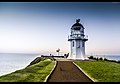
 The lighthouse, 25 September 1902 | |
 | |
| Location | Mokohinau Islands North Island New Zealand |
|---|---|
| Coordinates | 35°54′16.2″S 175°07′50.6″E |
| Tower | |
| Constructed | 1883[1] |
| Construction | stone tower |
| Automated | 1980 |
| Height | 14 metres (46 ft) |
| Shape | cylindrical tower with balcony and lantern |
| Markings | white tower, black balcony |
| Power source | solar power |
| Light | |
| First lit | 1883 |
| Focal height | 122 metres (400 ft) |
| Range | 19 nautical miles (35 km; 22 mi) |
| Characteristic | Fl W 10s. |
The lighthouse was built in 1883 and first lit during June of that year. Its isolated position, approximately 50 km northeast of Cape Rodney makes it one of the most distant lighthouses from the mainland.
During World War II, the lighthouse was turned off as the German destroyer suspected to be in the area laying mines.[4] The lighthouse was not relit until 1947.[5]
In 1980, the lighthouse was fully automated and the lighthouse keepers were withdrawn. The lighthouse is now monitored remotely from Wellington. The white light flashes every 10 seconds and can be seen for 19 nautical miles (35 km).[3]
See also
- List of lighthouses in New Zealand
References
- "The Hauraki Gulf Marine Park, Part 2". Inset to The New Zealand Herald. 3 March 2010. p. 15.
- "Mokohinau Islands lighthouse – Maritime NZ". www.maritimenz.govt.nz. Archived from the original on 16 July 2018. Retrieved 16 July 2018.
- Rowlett, Russ. "Lighthouses of New Zealand: North Island". The Lighthouse Directory. University of North Carolina at Chapel Hill. Retrieved 16 July 2018.
- "Mokohinau Island Lighthouse". www.newzealandlighthouses.com. Archived from the original on 16 July 2018. Retrieved 16 July 2018.
- Wright, Danielle (13 January 2012). "Leading lights in New Zealand". New Zealand Herald. ISSN 1170-0777. Archived from the original on 16 July 2018. Retrieved 16 July 2018.
External links
- Mokohinau Islands Lighthouse in Lighthouse Digest's Lighthouse Explorer Database
- Lighthouses of New Zealand Maritime New Zealand
- Mokohinau Lighthouse in the Auckland War Memorial Museum archives.
Lighthouses in New Zealand | ||
|---|---|---|
Italics indicate inactive sites. | ||
| North Island |
|  |
| South Island |
| |
| Authority control: Lighthouse identifiers |
|
|---|
This article about a New Zealand building or structure is a stub. You can help Wikipedia by expanding it. |
This lighthouse-related article is a stub. You can help Wikipedia by expanding it. |
На других языках
- [en] Mokohinau Islands Lighthouse
[ru] Маяк острова Мокохинау
Маяк острова Мокохинау (англ. Mokohinau Islands lighthouse) — маяк на небольшом острове Берджесс, входящем в состав архипелага Мокохинау региона Окленд Северного острова, Новой Зеландии. Маяк является самым отдалённым от береговой линии Новой Зеландии и находится в северной части при входе в залива Хаураки, приблизительно в 50 км к северо-востоку от Мыса Родни (англ.) (рус.. Маяк принадлежит и обслуживается Управлением безопасности морского судоходства Новой Зеландии (англ. Maritime New Zealand)[1].Другой контент может иметь иную лицензию. Перед использованием материалов сайта WikiSort.org внимательно изучите правила лицензирования конкретных элементов наполнения сайта.
WikiSort.org - проект по пересортировке и дополнению контента Википедии