fleet.wikisort.org - Lighthouse
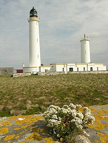
Muckle Skerry is the largest of the Pentland Skerries that lie off the north coast of Scotland. It is home to the Pentland Skerries Lighthouse.

 Pentland Skerries High and Low Lighthouses | |
 | |
| Location | Muckle Skerry Pentland Skerries Orkney Scotland United Kingdom |
|---|---|
| Coordinates | 58.690221°N 2.924735°W |
| Tower | |
| Constructed | 1794 |
| Built by | Thomas Smith, Robert Stevenson |
| Construction | stone tower |
| Automated | 1994 |
| Height | 36 m (118 ft) |
| Shape | cylindrical tower with balcony and lantern |
| Markings | white tower, black lantern, ochre trim |
| Power source | solar power |
| Operator | Northern Lighthouse Board[1][2] |
| Light | |
| First lit | 1820s rebuilt |
| Focal height | 52 m (171 ft) |
| Intensity | 710,000 candela |
| Range | 23 nmi (43 km) |
| Characteristic | Fl (3) W 30 s |
Muckle Skerry lies in the Pentland Firth at grid reference ND464782. It is the westernmost of the skerries. At one kilometre (five furlongs) long and rising to an elevation of 20 metres (65 feet) above sea level, it is sizable enough to be considered an island. However the notoriously bad weather of the firth has historically rendered Muckle Skerry uninhabitable and as such it is more often thought of as a skerry.
Pentland Skerries Lighthouse
Pentland Skerries Lighthouse was constructed in 1794 by the Commissioners of the Northern Lights. The engineers were Thomas Smith and his stepson Robert Stevenson (this was the first light that Stevenson officially worked on).
See also
- List of lighthouses in Scotland
- List of Northern Lighthouse Board lighthouses
References
- Rowlett, Russ. "Lighthouses of Scotland: Orkney". The Lighthouse Directory. University of North Carolina at Chapel Hill. Retrieved 26 May 2016.
- Pentland Skerries Northern Lighthouse Board. Retrieved 26 May 2016
External links
- Pentland Skerries Northern Lighthouse Board
- Northern Lighthouse Board
На других языках
[de] Muckle Skerry (Orkney)
Muckle Skerry ist eine Insel der Orkney. Sie ist die größte der Pentland Skerries, einer Gruppe von vier Schären im Pentland Firth. Bei einer Länge von 1,1 km ist Muckle Skerry maximal 600 m breit. Im Nordwesten befinden sich drei kleine, namenlose Seen. Muckle Skerry liegt 4,5 Kilometer südlich von South Ronaldsay und 7,1 Kilometer nordöstlich von Duncansby Head, der nordöstlichsten Spitze des schottischen Festlands.[1] Während 1881 noch 17 Einwohner gezählt wurden, ist Muckle Skerry heute unbewohnt.[1] Ein Landeplatz zum Anlegen von Booten befindet sich an der Nordostküste.[2]- [en] Muckle Skerry
[es] Muckle Skerry
Muckle Skerry es la isla más grande de cuantas forman el archipiélago de las Pentland Skerries, en la costa norte de Escocia. La isla alberga un faro, el Pentland Skerries Lighthouse.[fr] Muckle Skerry
Muckle Skerry est une île du Royaume-Uni située en Écosse. Elle est la plus grande et la plus occidentale des îles de l'archipel Pentland Skerries, à l'entrée est du Pentland Firth, détroit séparant l'Écosse des Orcades.[it] Muckle Skerry
Muckle Skerry è la più grande delle Pentland Skerries, (in lingua Scots muckle significa grande o largo), un gruppo di quattro piccole isole disabitate nell'arcipelago delle Orcadi, in Scozia. Si trova nel Pentland Firth, ed è la più occidentale delle quattro isole.Другой контент может иметь иную лицензию. Перед использованием материалов сайта WikiSort.org внимательно изучите правила лицензирования конкретных элементов наполнения сайта.
WikiSort.org - проект по пересортировке и дополнению контента Википедии