fleet.wikisort.org - Lighthouse
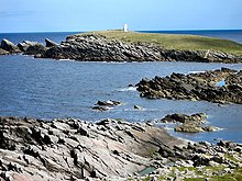
Perie Bard is one of the Shetland Islands. It is a small islet off the east coast of the island of Mousa.[2]

 Eastern tip of Mousa | |
 | |
| Location | Peerie Bard Mousa Shetland Scotland United Kingdom |
|---|---|
| Coordinates | 59.997108°N 1.157808°W |
| Tower | |
| Constructed | 1951 (first) |
| Foundation | concrete base |
| Construction | metal skeletal tower |
| Height | 6 metres (20 ft) |
| Shape | quadrangular tower covered by aluminium panels with light on the top |
| Markings | white tower |
| Power source | solar power |
| Operator | Mousa Nature Reserve[1] |
| Light | |
| First lit | 2000 (current) |
| Deactivated | 2000 (first) |
| Focal height | 20 metres (66 ft) |
| Range | 10 nmi (19 km; 12 mi) |
| Characteristic | Fl W 3s. |
Although named 'Perie Bard' on OS Maps, the name used in Shetland is "Peerie Bard".
The name is derived from the Shetland dialect words 'Peerie', meaning small, and 'Bard', meaning steep headland. The Muckle Bard, or large steep headland, is located on neighbouring Mousa.
The Mousa Lighthouse is located on the Peerie Bard. The lighthouse was first lit in 1951 and replaced one which had previously been located on the nearby headland of Noness
See also
- List of lighthouses in Scotland
- List of Northern Lighthouse Board lighthouses
References
- Rowlett, Russ. "Lighthouses of Scotland: Shetland". The Lighthouse Directory. University of North Carolina at Chapel Hill. Retrieved 31 May 2016.
- Haswell-Smith, Hamish (2004). The Scottish Islands. Edinburgh: Canongate. ISBN 978-1-84195-454-7.
External links
- Northern Lighthouse Board
 Media related to Peerie Bard at Wikimedia Commons
Текст в блоке "Читать" взят с сайта "Википедия" и доступен по лицензии Creative Commons Attribution-ShareAlike; в отдельных случаях могут действовать дополнительные условия.
Другой контент может иметь иную лицензию. Перед использованием материалов сайта WikiSort.org внимательно изучите правила лицензирования конкретных элементов наполнения сайта.
Другой контент может иметь иную лицензию. Перед использованием материалов сайта WikiSort.org внимательно изучите правила лицензирования конкретных элементов наполнения сайта.
2019-2025
WikiSort.org - проект по пересортировке и дополнению контента Википедии
WikiSort.org - проект по пересортировке и дополнению контента Википедии