fleet.wikisort.org - Lighthouse
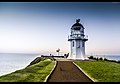
Baring Head Lighthouse is a concrete lighthouse at Baring Head in the Wellington Region of the North Island of New Zealand, with an LED beacon powered by mains electricity.[2] It is owned and operated by Maritime New Zealand, and can be accessed via walking tracks in the southern area of the East Harbour Regional Park, south of Wainuiomata.
 | |
 | |
| Location | Baring Head, North Island New Zealand |
|---|---|
| Coordinates | 41°24′29″S 174°52′16″E |
| Tower | |
| Constructed | 1935 |
| Construction | concrete tower |
| Automated | 1989 |
| Height | 12.2 metres (40 ft) |
| Shape | octagonal tower with balcony and lantern |
| Markings | white tower and lantern, greenish lantern dome |
| Power source | solar power |
| Operator | Maritime New Zealand[1] |
| Light | |
| First lit | June 1935 |
| Focal height | 87 metres (285 ft) |
| Range | 10 nautical miles (19 km; 12 mi) |
| Characteristic | Oc W 15s |
The lighthouse tower is 12.2 m tall (40 ft), but the hilltop elevation gives a focal height of 87 m (285 ft).[2] The light range is 10 nautical miles (19 km; 12 mi).
The lighthouse was built to be the main approach light to Wellington Harbour, as well as a coastal light for Cook Strait. Lit on 18 June 1935, it replaced the light at Pencarrow Head, which was decommissioned later that year.[2] The lighthouse was initially powered by a diesel generator but was converted to mains electricity in 1950.[3] The 1000 W light was fully automated in 1989 and demanned. In February 2005, the original lens was replaced by a flashing LED beacon visible from up to 18 kilometres (10 nmi; 11 mi).[3]
See also
- List of lighthouses in New Zealand
References
- Rowlett, Russ. "Lighthouses of New Zealand: North Island". The Lighthouse Directory. University of North Carolina at Chapel Hill. Retrieved 22 February 2016.
- "Baring Head Lighthouse". Maritime New Zealand website. Retrieved 5 January 2017.
- "Baring Head Lighthouse". (section "Operation of the Baring Head Light"). Retrieved 5 January 2017.
External links
 Media related to Baring Head Lighthouse at Wikimedia Commons
- Baring Head Lighthouse in Lighthouse Digest's Lighthouse Explorer Database
- Lighthouses of New Zealand Maritime New Zealand
Lighthouses in New Zealand | ||
|---|---|---|
Italics indicate inactive sites. | ||
| North Island |
|  |
| South Island |
| |
| Authority control: Lighthouse identifiers |
|
|---|
This article about a New Zealand building or structure is a stub. You can help Wikipedia by expanding it. |
This lighthouse-related article is a stub. You can help Wikipedia by expanding it. |
Другой контент может иметь иную лицензию. Перед использованием материалов сайта WikiSort.org внимательно изучите правила лицензирования конкретных элементов наполнения сайта.
WikiSort.org - проект по пересортировке и дополнению контента Википедии