fleet.wikisort.org - Lighthouse
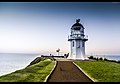
Anchored firmly at the end of New Zealand's longest sand spit, the Farewell Spit Lighthouse guides vessels entering Cook Strait from the west and south.[1] The LED rotating beacon flashes white or red, once every 15 seconds. It has a range of 19 nautical miles (35 km; 22 mi).[2] Red is shown to warn approaching vessels of extensive shoaling.[2] Standing 27 metres (89 ft) tall, the tower raises higher than most lighthouses (on cliffs or headlands), because the shifting sands it is built on are almost at sea level.[3] It is constructed of an open steel lattice to withstand abrasive sand and salt-laden winds.
 | |
 | |
| Location | Farewell Spit, Tasman District, New Zealand |
|---|---|
| Coordinates | 40°32′46″S 173°00′34″E |
| Tower | |
| Constructed | 1896 |
| Construction | metal (artificial physical structure) |
| Automated | 1984 |
| Height | 27 m (89 ft) |
| Markings | grey (tower), orange (top) |
| Power source | solar power |
| Light | |
| First lit | 19 January 1897 |
| Focal height | 30 m (98 ft) |
| Lens | second order Fresnel lens |
| Light source | rotating LED beacon |
| Range | 19 nmi (35 km; 22 mi) (red) |
| Characteristic | Fl WR 15s |
| Original lighthouse | |
 | |
| Constructed | 1870 |
| Construction | lumber |
| Height | 34.4 m (113 ft) |
| Markings | white (tower) |
| First lit | 17 June 1870 |
| Deactivated | 17 January 1897 |
| Focal height | 36.6 m (120 ft) |
| Lens | second order Fresnel lens |
| Range | 17 nmi (31 km; 20 mi) |
| Characteristic | Fl WR 60s |
History
The need for a lighthouse was identified in 1856, in the days of early European settlement,[4] in response to a growing number of stranding and wrecks.[5] The drifting sand dunes, interspersed with fresh water lagoons, are low lying, with an extensive shoal area on the southern side.[6] The lighthouse is located near Bush End Point, almost at the end of Farewell Spit. Initially, in 1870, a wooden structure was built, however, it was no match for the abrasive sand and salt-laden winds. It was replaced by a new lighthouse on a steel lattice construction in 1897.[3]
The original oil-burning lamp was converted to a 1000-watt electric lamp in 1954, and the diesel power supply replaced by a buried mains electricity cable along the spit in 1966. The original lamp was changed to a modern rotating beacon with a 50-watt tungsten halogen bulb in 1999.[7] In 2019, the lighthouse was converted to solar power, and the mains supply disconnected.[8]
The spit was a barren and uninviting place to be a lighthouse keeper.[9] Sand got into everything. The lighthouse sits on a low vegetated dune; an oasis surrounded by an ever-changing landscape, reshaped by incessant wind and tide.[10] Early attempts at gardening were swamped during exceptional high tides, or plants were eaten by marauding weka.[4]
Since being de-manned and automated in 1984, the keeper’s houses are used by the Department of Conservation and tour groups.[11]
The keepers include: Alexander Greenlees McKinlay (2nd assistant, 1871–1872), James Nelson (c. 1870s), Robert Leighton (c. 1916), Hugh Jamieson (1946–1949).[12]
Access
The public is not permitted to climb the lighthouse structure. Farewell Spit / Onetahua is a wildlife sanctuary run by the Department of Conservation. The area is an important bird nesting area, especially for Australasian gannet. It is closed to casual visitors, and public access to the lighthouse site is restricted to people on an ecotour.[2]
Operations
The lighthouse is operated by Maritime New Zealand. With a focal height of 30 metres (98 ft) above sea level, the light can be seen for 19 nautical miles (35 km; 22 mi).[2] Its characteristic is either a white or red flash every fifteen seconds, depending on where you view it from. It is a sector light. The red flashes warn a vessel it is in a danger of hitting the shoal.[9] The white sector shines from 113° to 299° and 333° to 110°; the red from 299° to 333°.[13][14][15]
Gallery
 Exposed to sand and salt-laden winds
 Keeper’s houses
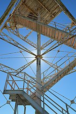 Open lattice structure


References
- Rowlett, Russ. "Lighthouses of New Zealand: South Island". The Lighthouse Directory. University of North Carolina at Chapel Hill. Retrieved 3 June 2022.
- "Farewell Spit lighthouse – Maritime NZ". www.maritimenz.govt.nz. Archived from the original on 9 June 2022. Retrieved 3 June 2022.
- "Farewell Spit Lighthouse". Maritime New Zealand, Lighthouses of New Zealand. Archived from the original on 4 June 2022. Retrieved 4 June 2022.
- Petyt, Chris (1999). Farewell Spit a Changing Landscape: History and Natural History. Takaka, N.Z.: Terracottage Books. pp. 54, 63. ISBN 0473055392.
- Newport, J. N. W. (November 1971). "Farewell Spit Lighthouse". Nelson Historical Society Journal. 1 (5): 7–8. Archived from the original on 20 April 2022. Retrieved 4 June 2022.
- Hydrographic Department, Great Britain (2001). New Zealand Pilot. Taunton, England: Hydrographer of the Navy. ISBN 0707712912.
- History of the lighthouse (Information panel at the lighthouse keeper's house). Bush-end Point: Maritime New Zealand.
- "Farewell Spit lighthouse". Maritime New Zealand. Archived from the original on 9 June 2022. Retrieved 2 July 2022.
- Nalder, Guinevere (December 2007). Southern Lights - The Scottish Contribution to New Zealand's Lighthouses. Dunbeath: Whittles Publishing Ltd. ISBN 978-1-84995-156-2. Wikidata Q112554192.
- The Long Sweeping Sand Spit (Interpretation panel Port Pūponga, at base of the spit). Fossil Point: Department of Conservation. 2016.
- "Farewell Spit Tours discover lighthouse". Farewell Spit Tours. 2022. Archived from the original on 26 January 2022. Retrieved 3 June 2022.
- "Lighthouse Explorer". Lighthouse Digest Magazine. Archived from the original on 16 October 2018. Retrieved 4 June 2022.
- Marine Division, Ministry of Transport, New Zealand Nautical Adviser (2022). New Zealand nautical almanac. Wellington, N.Z.: Land Information New Zealand.
- "K4182 Cape Farewell / Farewell Spit Bush-end Point". Online list of lights. Archived from the original on 29 September 2022. Retrieved 4 June 2022.
- "Farewell Spit (South Island) Light ARLHS NZL-022". List of the world's lighthouses by the Amateur Radio Lighthouse Society. Archived from the original on 3 June 2022. Retrieved 4 June 2022.
Lighthouses in New Zealand | ||
|---|---|---|
Italics indicate inactive sites. | ||
| North Island |
|  |
| South Island |
| |
| Authority control: Lighthouse identifiers |
|
|---|
Другой контент может иметь иную лицензию. Перед использованием материалов сайта WikiSort.org внимательно изучите правила лицензирования конкретных элементов наполнения сайта.
WikiSort.org - проект по пересортировке и дополнению контента Википедии